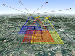
 依現今攝影測量的範疇可以分為兩類:航空攝影測量和近景攝影測量。航空攝影測量即在飛機上裝載量測型相機,於空中拍照後透過地面控制、重疊像對以及光束法空中三角平差演算,即可恢復拍攝瞬間相機的成像幾何以及相機之成像位置,再以此為基礎來解算所拍攝影像物體之物空間座標。現代的攝影測量,多在飛機上另外裝備GPS接收儀和慣性導航系統(INS),如左圖所示:飛機由至少四顆衛星便可以定位,以及IMU來定向,透過直接地理定位的方式,可以快速地獲取像點之物空間概略位置,同時,亦能減少在光束法空中三角平差中所需的地面點數量。
The field of photogrammetry in present can be classified into Aerial Photogrammetry and Close-range Photogrammetry. Aerial Photogrammetry, by mounting the metric camera under the airplane, takes photos/images in the air. Along with the ground control points and the captured stereo images, the orientation and position of exposure of the cameras can be then obtained. The information is then used to calculate 3D coordinates of the sensed object points.Recently, the airborne Photogrammetry system integrates the GPS and INS. As the left figure shows, by receiving signals from at least four satellites, the position of the airplane can be determined. On the other hand, the INS provides the orientation information of the airplane. Thus direct geo-referencing works. This also decreases the demands of the number of ground control points for Photogrammetry surveys.
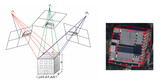
航照影像更進一步能夠產製數值地形模型(DTM)、數值表面模型(DSM)等等,多時期的航照經過對位後,能用來觀察地表的變遷,以及歷史人文的變化。除此之外,航照影像亦能用來進行建物模型之製作,例如由本實驗室所提出的浮測模型法,如下圖所示:
Furthermore, aerial images can be used to generate the DTM, DSM, and so on. Multi-temporal aerial images after the registration can be used to observe the change of terrain, history and culture. Besides, aerial images can be used to generate the stereoscopic model. For example, our laboratory develops a theory of floating modeling in Photogrammetry for 3D building reconstruction as shown in the below figure.
近景攝影測量則是以近距離來拍攝景物,透過攝影測量的原理進行許多應用,例如建築工程、地形測繪等等都有相關,因為近景的尺度大,因此所拍攝景物的影像更細緻,可用在古蹟的重建,如下圖所示:
Close-range photogrammetry takes images in a much closer range rather than aerial photogrammetry. The principles of the algorithms for applications benefit from the aerial Photogrammetry algorithms. Many applications such as architecture construction and terrain surveying have been applied. Since the scale is larger, the images record more details of the sensed objects. An application is then used to rebuild the historical site as shown in the below figure.
根據近景攝影測量的原理,本實驗室發展了一套系統,命名為可攜式全景影像測繪系統(Portable Panoramic Image Mapping System),英文縮寫為PPIMS,其乃將8台相機和一部GPS接收儀裝載在一個特製的平台上,如下圖所示:
Our lab has also developed a close-range system, namely Portable Panoramic Image Mapping System (PPIMS). It equipped with eight single-lens cameras to capture panoramic images and a GPS receiver for positioning. As the below figure shows.
其目的是為了能即時擷取三維空間資訊,並針對車載之移動式測繪系統無法進入之地區所設計。例如嚴重受創之山間村落、天然災害發生之地點。
This system is specially designed for rapid collection of spatial information in some difficult accessing areas by vehicle-based mapping systems, such as rugged terrains, forest areas, heavily damaged disaster areas, and crowed places etc. Future works will upgrade the hardware for example, remote control shooting to ensure all the cameras exposure nearly at the same time.